Mapviewer - SH Customer Density Semi-Static Map
Prerequisites
You must have the sh schema and the spatial demo files installed.
You can also do it with your own map : MapBuilder - Import of a Shapefile Map
Articles Related
Create the spatial data
As sys :
GRANT SELECT ANY TABLE TO MVDEMO;
As mvdemo :
create table t_sh_customer_density as (
select STATE_ABRV,
(
select count(distinct T245.CUST_ID)
from
     SH.COUNTRIES T175,
     SH.CUSTOMERS T186,
     SH.SALES T245
where
  T175.COUNTRY_ID = T186.COUNTRY_ID
  and T175.COUNTRY_NAME = 'United States of America'
  and T186.CUST_ID = T245.CUST_ID
  and state_abrv = T186.CUST_STATE_PROVINCE
) CountCustomers,
geom
from
mvdemo.states
)
insert into USER_SDO_GEOM_METADATA values (
    'sh_customer_density',
    'GEOM',
        MDSYS.SDO_DIM_ARRAY(MDSYS.SDO_DIM_ELEMENT('X', -180, 180, .00000005),
                            MDSYS.SDO_DIM_ELEMENT('Y', -90, 90, .00000005)),
        8307);

create index t_sh_customer_density_SDX on t_sh_customer_density(GEOM)
indextype is mdsys.spatial_index;
Create the Bucket Style

Create the theme
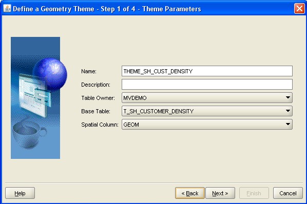

Set the attributes of theme
With Oracle Maps, labels are manifest as tool-tips on mouse-over the feature on the map.

Preview of the theme
cx : -96.554346 cy : 38.987208 height : 42.081234

Create the base map

Create the Map Tile Layer
Location :
- In Map Builder / node Tile Layers
- In MapViewer : Admin (Type the oc4j admin credentials) / Management / Manage Map Tile Layers / Create

Zoom Level Definition :
| Level | Scale | Tile width |
|---|---|---|
| 0 | 1.5E8 | 91.71616894864779 |
To know more about how to define the zoom level : Point Center and Zoom Level Definition
Show the map in a web page
The tutorial is provided with the installation of MapViewer on this url :
<script language=javascript>
  function showMap()
  {
    var baseURL  = "http://"+document.location.host+"/mapviewer";
    var mapCenterLon =  -96.554346;
    var mapCenterLat =  38.987208;
    var mapZoom      =  0;
    var mpoint = MVSdoGeometry.createPoint(mapCenterLon,mapCenterLat,8307);
    var mapview = new MVMapView(document.getElementById("map"), baseURL);
    mapview.addMapTileLayer(new MVMapTileLayer("mvdemo.SH_CUST_DENSITY_MAP"));
    mapview.setCenter(mpoint);
    mapview.setZoomLevel(mapZoom);
    mapview.display();
  }
</script>
Support
See this article on how to retrieve debug information : Mapviewer debugging - log
interface not supported without a spatial index
You have forgotten to create the spatial index.
Message:Exception while querying theme: THEME_SH_CUST_DENSITY
Description: Nested exception is:
java.sql.SQLException: ORA-13226: interface not supported without a spatial index
ORA-06512: at "MDSYS.MD", line 1723
ORA-06512: at "MDSYS.MDERR", line 8
ORA-06512: at "MDSYS.SDO_3GL", line 1173